Drone Simulator Flight barbados
A virtual drone view of Barbados in Microsoft Flight Simulator!
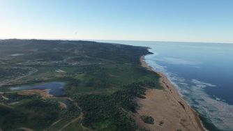
This drone video is something a little different! Not a real drone flight over the island but rather a virtual flight in Microsoft Flight Simulator!
Starting at the international airport in the south of Barbados we head east over fields and residences, before swinging north and following the coastline. The video reveals how lush and rugged this part of Barbados is. Atlantic Ocean waves roll onto sandy shores as we fly over the Long Pond estuarine area.
Reaching Barbados’ northern tip we head back south, down the calmer western coast. The marinas at Port St. Charles and Port Ferdinand look beautiful as we fly by. Continuing south we arrive at our capital city Bridgetown, then explore the south coast before returning to the airport.
Microsoft Flight Simulator does an amazing job of creating virtual views of the world using Bing Maps to generate photorealistic representations of landscapes and buildings.
similar Barbados drone videos...
islandwide
Reviewed by: kathy lynn ward