Harrison Point Lighthouse barbados
Fly around the lighthouse and explore the ruggedly beautiful coastline!
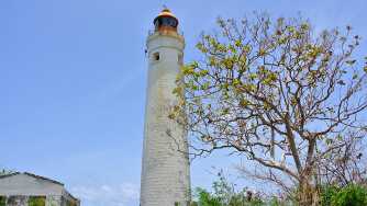
I’ll admit to being a bit biased to this video on account of its main content…. I love lighthouses! But it is a rather good video, despite the neglected nature of the Harrison Point lighthouse.
We start off at the base of the lighthouse and soar up and around the structure, revealing the rugged coastline that this lighthouse was built to keep vessels clear of, warning approaching ships of danger and guiding them safely down the coast.
Moving offshore we see that the cliffs were hiding a secret cove! That’s one of the joys of drone exploration, we find lots of these hidden gems.
Back inland and flying backwards an expansive drone shot shows the sugar cane fields that surround the lighthouse. It was sugar that made Barbados a well-known and wealthy colony in the 18th and 19th centuries. And the island remains a producer of high quality sugar and the world’s best rums.
The close-up of the lantern room and widows walk is stunning, inviting you to visit and climb to the top!
As we fly away from Harrison Point we can just make out the modern cement factory in the distance. Old technology juxtaposed against new. A sign of progress and a reminder to respect the technology and ingenuity of generations past.
And the final view is that which vessels being guided by the lighthouse might have seen. What a reassuring sight it would have been.
Thanks to the Above Barbados team for providing this intriguing drone footage.
Video created by: above barbados
Reviewed by: kathy lynn ward