St. Lawrence & Top Rock barbados
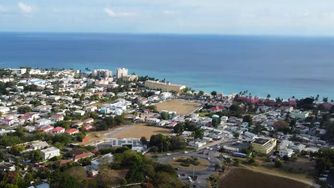
Aerial view of the popular St. Lawrence Gap area.
Local real estate broker Richie Quintyne provides this wonderful drone exploration of the St. Lawrence Gap, Top Rock, and Graeme Hall areas on the south coast of Barbados.
As you’ll see, this part of the island is heavily developed with many hotels along the coastline. This was once a residential area but as tourism started to boom in the 1960’s it gradually became more commercialised, starting with small family hotels and growing into a wonderful collection of oceanfront hotels, all-inclusive resorts, seaside restaurants, and bars & nightclubs. There are still many private accommodations for those visitors who like the vibe of the area but aren’t seeking a hotel experience.
Richie points out the existing swamp area which is planned to become a luxury marina.
Leaving St. Lawrence Gap we head to the Top Rock area where we spot some new condos and see the road leading to Maxwell and Oistins (site of the popular fish fry!). We can also spot the South Point Lighthouse in the distance.
Heading into Graeme Hall we see crop fields and can appreciate the difference between this more agricultural area and the development directly on the coastline. For such a small island there is still some remarkable diversity.
This is an informative video with smooth drone footage and great commentary from Richie.
similar Barbados drone videos...
islandwideVideo created by: richie quintyne
Reviewed by: kathy lynn ward