North Point Lighthouse barbados
Maritime heritage meets modern aerial exploration on this drone tour!
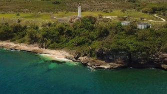
Let’s journey to the northernmost tip of Barbados - where wind, sea, and history converge - to rediscover one of the island’s maritime sentinels: Harrison Point Lighthouse.
Our drone glides towards the rocky shoreline, where waves crash against jagged outcrops and turquoise water surges into crevices carved by time. Rising just inland, the lighthouse stands tall. For decades, it cast its beam across this wild coastline, warning ships of hidden dangers and guiding them safely along this tricky coastline.
As we climb the cliffside by air, the tower seems to meet us with a quiet vigilance. Though no longer operational, Harrison Point still commands the landscape with a quiet dignity. Built in 1925, it’s the newest of Barbados’s four historic lighthouses - a monument to a time when seafaring defined the island’s fortunes.
Despite the wear of years and lack of recent upkeep, the lighthouse remains visually striking. From the lantern platform, the panorama is breathtaking: rugged headlands, restless sea, and the open sky stretching to the horizon. It’s easy to imagine the keepers once stationed here, maintaining the light through storms and solitude - an enduring part of the island’s connection to the wider world.
Circling back to the coastline, the terrain reveals its raw, untamed beauty. This part of St. Lucy Parish offers some of the most dramatic natural scenery on the island, perfect for exploration and reflection.
Back above the lighthouse, we pass over the abandoned keeper’s quarters, their ruins a reminder of the lives once lived in service to maritime safety. Below, our drone operators are visible on the parapet - modern explorers capturing the spirit of a place shaped by generations past.
In colonial times, lighthouses like this one played a pivotal role in Barbados’s economy and defense. They welcomed merchant ships laden with goods, lit the way for British naval vessels, and oversaw the export of rum, sugar, and molasses—key products in the island’s transatlantic trade. They also stood as silent sentries during naval conflicts, helping secure Britain’s foothold in the Caribbean.
As the drone pulls back, the landscape opens up, and the contrast of ocean blues and inland greens creates a stunning natural palette.
As a special bonus we also are treated to bird’s eye views of the island’s east coast and Santosha Resort.
This flight is a meeting point of historic maritime technology and modern aerial perspective, giving us a renewed appreciation for the island’s past and the enduring beauty of its remote areas.
similar Barbados drone videos...
historic sites
Reviewed by: kathy lynn ward