The Heart of the Island barbados
Showcasing the island's endless capacity to surprise and inspire!
This captivating aerial journey begins at sunrise as the day’s first light reveals lush landscapes leading to tranquil bays. As the day begins, so too does our drone exploration.
We glide seamlessly from sea to land, soaring over expansive open fields that reveal how much of Barbados’ natural beauty remains despite modern development. These peaceful trails welcome hikers, fishermen, and cyclists, with the occasional adventurous driver testing their vehicle’s limits on this rugged route.
Banana trees and swaying palms frame the Atlantic Ocean stretching beyond the hills. The narrator reminds us that of Barbados’ eleven parishes only two - St. Thomas and St. George - are untouched by the ocean. We truly are a nation where the sea is never far away.
The aerial view captures the excitement of rally cars navigating the island’s more accessible roads, racing past historic landmarks and sugarcane fields.
Our journey continues at St. John’s Parish Church, a popular stop for tour buses, inviting visitors to soak up the panoramic views and admire the Gothis design of this historic church. Like many Anglican churches across Barbados, it sits prominently on a hilltop - a location that reflected the colonial establishment’s desire to assert its presence and social dominance across the island.
Ancient mahogany trees embrace the church like protective guardians, while a magnificent flamboyant tree in full bloom adds a brilliant splash of red against the surrounding greenery.
Moving inland into St. George parish, the landscape maintains its verdant character while revealing how residential and commercial development has thoughtfully integrated with the natural terrain.
The lush feel continues in the adjoining parish of St. Thomas, as we aerially trace the winding ‘Jack in the Box gully’.
The scene shifts dramatically as the drone heads south to St. Philip parish and the bustling commercial hub of Six Roads. Here, shops, restaurants, gas stations, and supermarkets create a vibrant center of activity, reflecting this area’s status as part of the island’s fastest-growing parish.
Just a short drive away - yet greatly separated by time - stands the Carrington Sugar Factory, a powerful reminder of Barbados’ prominence as a major sugar producer during the 18th and 19th centuries.
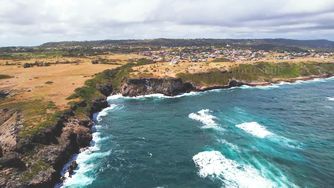
We continue to another historical landmark at Ragged Point Lighthouse, which for generations guided ships safely along this challenging stretch of coast. From here, the dramatic coastline unfolds in all its rugged glory.
The final scenes capture towering cliffs standing resolute against the Atlantic’s relentless waves in an impressive display of nature’s raw power. Nearby, modern wind turbines harness another of nature’s forces, representing Barbados’ commitment to renewable energy. These contemporary structures create a fascinating parallel to the historic windmills that once dotted sugar plantations, using the same Atlantic winds to power the grinding of sugarcane.
This remarkable drone journey weaves together space and time, revealing how Barbados honors its rich heritage while embracing a sustainable future.
similar Barbados drone videos...
islandwideVideo created by: from the sky
Reviewed by: kathy lynn ward